 News
News
Marsh Guides
The National Estuarine Research Reserve (NERR) system was created for the collective goal of protecting and studying estuarine systems in the U.S. Unfortunately, estuaries are being threatened by the dangerously-rapid rate of sea level rise (SLR). Salt marsh habitats are especially at risk due to increasing water levels. Because they naturally build peat layers by trapping sediment from the tides and accumulating decomposing plant matter, marshes are generally able to keep pace with historic rates of SLR. However, current SLR is far outpacing the normal vertical marsh growth. Thus, coastal salt marshes are at risk of “drowning.” The drowning of these saline grasslands is alarming for numerous reasons. Without healthy marshes, the many ecosystem services marshes normally provide, including nurseries for economically important fisheries, improved water quality, and reduced flooding and erosion, are lost. The loss of healthy marshes also means the loss of an important carbon sink. Marshes act as carbon sinks by trapping carbon dioxide in the sediment and plants. As marshes drown, two issues arise: previously trapped carbon dioxide is released back into the atmosphere and atmospheric carbon dioxide is no longer removed and stored. If more carbon dioxide sits in the atmosphere, climate change will continue to worsen. Worse climate change will then lead to greater SLR, which will result in the loss of more marshes. It’s a distressing and self-perpetuating cycle.
In order to gain greater insight into the effects of SLR on salt marshes, and in turn work toward our shared mission of protecting and studying estuarine systems, a group of New England reserves and other research institutions have developed two “How to” guides. These guides are designed to advance the research and monitoring of salt marsh vegetation, which is integral to understanding the impacts of rapidly rising oceans. As water levels rise, plant composition shifts, and marshes migrate further inland. Low marsh plants begin to take over areas previously inhabited by high marsh plants. However, high marshes often can’t move due to man-made barriers and, as a result, begin to shrink. By creating unified methods of studying vegetation, the two guides serve as a tool to track these and other SLR-related changes in salt marshes. Dr. Kenneth Raposa, NBNERR’s Research Coordinator, took part in this joint effort along with researchers at the University of New Hampshire and the Great Bay, Waquoit Bay, and Wells National Estuarine Research Reserves.
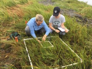
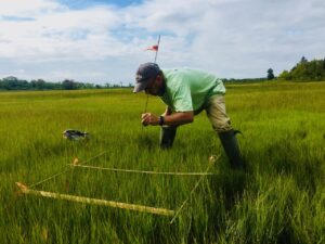
The first guide, titled “A Guide to Integrate Plant Cover Data from Two Different Methods: Point Intercept and Ocular Cover,” addresses the lack of consensus on how to estimate plant cover in tidal marshes. There are currently two common methods of cover estimation: point intercept (PI) and ocular cover (OC). The PI method calculates cover by noting the type of vegetation present at 50 fixed points within a 1-m2 plot. The OC method uses visual estimates of vegetation abundance within a 1-m2 plot that add up to 100% (e.g., “I see 90% salt marsh hay and 10% sea lavender in this plot”). Both methods are widely used for vegetation monitoring, which can confound interpretation when making comparisons across methods. This guide uses a statistical relationship between the two methods to transform PI data to be more compatible with OC data, thus allowing data from either method to be compared and analyzed effectively.
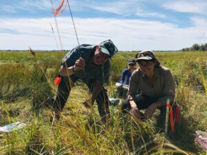
The second guide, titled “‘How to’ Guide for Synthesizing NERRs Marsh Monitoring Data” demonstrates how to synthesize salt marsh plant community data from the national reserve system. Since understanding the effects of climate change is a top priority, the guide spotlights the NERR Sentinel Sites Program (SSP). This program monitors long-term changes in plant distribution with water level changes associated with SLR. Reserves across the nation participate in the SSP, so methodologies can vary at each site (think PI vs. OC estimates). This guide addresses these discrepancies and breaks down the steps to catalogue, standardize, and summarize data from one or multiple sites.
Although they focus specifically on plant community data from NERRs, these guides may also be beneficial in designing protocols and analyses for other monitoring projects. It is the ultimate hope of the authors that they provide instructive, user-friendly tools to help further study and mitigate the effects of climate change on tidal salt marshes.